![](/images/other/stat-length.png)
![Trail On foot Lomnice nad Lužnicí - naučná stezka Velký lomnický - Photo](https://media.geolcdn.com/t/1900/400/9e7e6691-bdef-4f62-9949-fe34e4ff8ccb.jpeg&format=pjpeg&maxdim=2)
naučná stezka Velký lomnický
SityTrail - itinéraires balisés pédestres
Tous les sentiers balisés d’Europe GUIDE+
![Length](/images/other/stat-length.png)
Length
3.3 km
![Max alt](https://static1.geolcdn.com/siteimages/upload/files/1508320355ic_sort_altitude_max_24dp.png)
Max alt
440 m
![Uphill gradient](https://static1.geolcdn.com/siteimages/upload/files/1508320355ic_sort_den_pos_24dp.png)
Uphill gradient
34 m
![Km-Effort](/images/other/stat-length.png)
Km-Effort
3.8 km
![Min alt](https://static1.geolcdn.com/siteimages/upload/files/1508320355ic_sort_altitude_min_24dp.png)
Min alt
425 m
![Downhill gradient](https://static1.geolcdn.com/siteimages/upload/files/1508320355ic_sort_den_neg_24dp.png)
Downhill gradient
44 m
![Boucle](https://static1.geolcdn.com/siteimages/upload/files/16400158638029165_repeat_loop_refresh_sync_direction_icon.png)
Boucle
No
Signpost
Creation date :
2025-02-07 07:15:18.124
Updated on :
2025-02-07 07:15:18.124
![On foot](https://static1.geolcdn.com/sitytour/trail-icons/100.png)
51m
Difficulty : Easy
![Scan this QR Code to open this trail in the SityTrail application](https://capi.geolives.com/qq0zvz2zws4bq2lad0pu/sitytour/trails/4344828/qr.png?size=200)
FREE GPS app for hiking
About
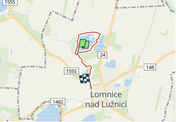
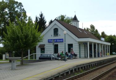
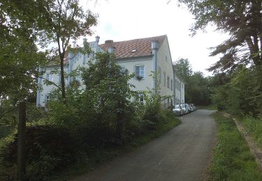
Trail On foot of 3.3 km to be discovered at Southwest, Jihočeský kraj, Lomnice nad Lužnicí. This trail is proposed by SityTrail - itinéraires balisés pédestres.
Description
Oficiální stránka města.
Website: https://www.lomnice-nl.cz/turista/priroda/naucna-stezka-velky-a-maly-lomnicky/
Positioning
Country:
Czech Republic
Region :
Southwest
Department/Province :
Jihočeský kraj
Municipality :
Lomnice nad Lužnicí
Location:
Unknown
Start:(Dec)
Start:(UTM)
478692 ; 5437701 (33U) N.
Comments
Trails nearby
![Trail On foot Mažice - Mažická naučná stezka - Photo](https://media.geolcdn.com/t/375/260/16fef0e7-7257-4b99-8729-a923498d289a.jpeg&format=jpg&maxdim=2)
![On foot On foot](https://static1.geolcdn.com/sitytour/trail-icons/100.png)
Mažická naučná stezka
On foot
Easy
Mažice,
Southwest,
Jihočeský kraj,
Czech Republic
![](/images/other/stat-length.png)
4 km | 4.2 km-effort
57min
![](https://static1.geolcdn.com/siteimages/upload/files/16400158638029165_repeat_loop_refresh_sync_direction_icon.png)
No
![Trail On foot Nová Ves - Vidov - Hůrka - Photo](https://media.geolcdn.com/t/375/260/a002da0c-6900-4fa2-8565-48e5dba76a10.jpeg&format=jpg&maxdim=2)
![On foot On foot](https://static1.geolcdn.com/sitytour/trail-icons/100.png)
Vidov - Hůrka
On foot
Easy
Nová Ves,
Southwest,
Jihočeský kraj,
Czech Republic
![](/images/other/stat-length.png)
3.1 km | 3.5 km-effort
47min
![](https://static1.geolcdn.com/siteimages/upload/files/16400158638029165_repeat_loop_refresh_sync_direction_icon.png)
No
![Trail On foot Vlkov - [Z] Veselí nad Lužnicí - Vlkov - Photo](https://media.geolcdn.com/t/375/260/5f369528-2855-4942-97de-c16c1e2154da.jpeg&format=jpg&maxdim=2)
![On foot On foot](https://static1.geolcdn.com/sitytour/trail-icons/100.png)
[Z] Veselí nad Lužnicí - Vlkov
On foot
Easy
Vlkov,
Southwest,
Jihočeský kraj,
Czech Republic
![](/images/other/stat-length.png)
5.8 km | 6.5 km-effort
1h 28min
![](https://static1.geolcdn.com/siteimages/upload/files/16400158638029165_repeat_loop_refresh_sync_direction_icon.png)
No
![Trail On foot Rudolfov - NS Člověk a krajina - Photo](https://media.geolcdn.com/t/375/260/369a485c-e57e-46fc-ae3d-057ccdf1d278.jpeg&format=jpg&maxdim=2)
![On foot On foot](https://static1.geolcdn.com/sitytour/trail-icons/100.png)
NS Člověk a krajina
On foot
Easy
Rudolfov,
Southwest,
Jihočeský kraj,
Czech Republic
![](/images/other/stat-length.png)
6.3 km | 7 km-effort
1h 35min
![](https://static1.geolcdn.com/siteimages/upload/files/16400158638029165_repeat_loop_refresh_sync_direction_icon.png)
No
![Trail On foot Třeboň - Stezka zdraví Třeboň - Hrádeček - Photo](https://media.geolcdn.com/t/375/260/cd7e2138-b4a5-440c-9654-077f5e1efe37.jpeg&format=jpg&maxdim=2)
![On foot On foot](https://static1.geolcdn.com/sitytour/trail-icons/100.png)
Stezka zdraví Třeboň - Hrádeček
On foot
Easy
Třeboň,
Southwest,
Jihočeský kraj,
Czech Republic
![](/images/other/stat-length.png)
3.8 km | 4.2 km-effort
57min
![](https://static1.geolcdn.com/siteimages/upload/files/16400158638029165_repeat_loop_refresh_sync_direction_icon.png)
Yes
![Trail On foot Hluboká nad Vltavou - [Ž] Munice - Pod Janečkem - Photo](https://media.geolcdn.com/t/375/260/419a5c8c-be46-4e45-ba12-1064ebe743d7.jpeg&format=jpg&maxdim=2)
![On foot On foot](https://static1.geolcdn.com/sitytour/trail-icons/100.png)
[Ž] Munice - Pod Janečkem
On foot
Easy
Hluboká nad Vltavou,
Southwest,
Jihočeský kraj,
Czech Republic
![](/images/other/stat-length.png)
4.6 km | 6.7 km-effort
1h 31min
![](https://static1.geolcdn.com/siteimages/upload/files/16400158638029165_repeat_loop_refresh_sync_direction_icon.png)
No
![Trail On foot Chlum u Třeboně - NS Mikuláše Rutharda - Photo](https://media.geolcdn.com/t/375/260/8b4e12c5-eab4-465c-9f20-2cef165ac95c.jpeg&format=jpg&maxdim=2)
![On foot On foot](https://static1.geolcdn.com/sitytour/trail-icons/100.png)
NS Mikuláše Rutharda
On foot
Easy
Chlum u Třeboně,
Southwest,
Jihočeský kraj,
Czech Republic
![](/images/other/stat-length.png)
10.5 km | 12.1 km-effort
2h 45min
![](https://static1.geolcdn.com/siteimages/upload/files/16400158638029165_repeat_loop_refresh_sync_direction_icon.png)
No
![Trail On foot Novosedly nad Nežárkou - [Z] Stará Hlína - Pomník E. Destinnové - Photo](https://media.geolcdn.com/t/375/260/6bc1994f-27bd-4395-9bdd-29ba1b36d733.jpeg&format=jpg&maxdim=2)
![On foot On foot](https://static1.geolcdn.com/sitytour/trail-icons/100.png)
[Z] Stará Hlína - Pomník E. Destinnové
On foot
Easy
Novosedly nad Nežárkou,
Southwest,
Jihočeský kraj,
Czech Republic
![](/images/other/stat-length.png)
3.7 km | 4.1 km-effort
55min
![](https://static1.geolcdn.com/siteimages/upload/files/16400158638029165_repeat_loop_refresh_sync_direction_icon.png)
No
![Trail On foot Vlkov - naučná stezka Veselské pískovny - Photo](https://media.geolcdn.com/t/375/260/c5f4c10b-17a6-48ec-a525-5a5a6d481dd0.jpeg&format=jpg&maxdim=2)
![On foot On foot](https://static1.geolcdn.com/sitytour/trail-icons/100.png)
naučná stezka Veselské pískovny
On foot
Easy
Vlkov,
Southwest,
Jihočeský kraj,
Czech Republic
![](/images/other/stat-length.png)
4.7 km | 5 km-effort
1h 7min
![](https://static1.geolcdn.com/siteimages/upload/files/16400158638029165_repeat_loop_refresh_sync_direction_icon.png)
No